(occasionally by the Air Cadets). Go to the Events page for dates.
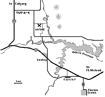
Cowley is reachable mainly from the Crowsnest highway (#3) in the southwest corner of Alberta, Canada. Turn north on the east side of the village of Cowley, then left at the T-junction once you have crossed the bridge over the west end of the Oldman reservoir. Follow Old Airport Rd around to the north 5.1 km (3 mi) and watch for the airfield and campground one field over to the east side.
For drivers coming from Calgary, an alternate
and very, very scenic route is Highway 22 south. This
is one of the most beautiful stretches of highway in Canada,
bar none! The turnoff to the airfield is Township Road 8-4, about
16 km south of the bridge over the Oldman River and the next
road south of Chapel Rock Rd. If you go too far and come out
on Hwy 3, turn east to get to Cowley village and approach from
the south. As you drive south and near the turn-off, you will
see the Porcupine Hills to the east gradually peter out until
all that remains are some tree-covered knolls. The airfield (which
you can't see for the rising ground in the way) is opposite the
last knoll. As you near the last knolls while driving south you
will see a gravel road going east up over the low hill. Turn
left and follow it until you come to a prominent intersection
(there is a farm on the NE side with a tall dark blue grain silo).
Turn south on Old Airport Rd for 3.2 km and you will see the
airfield and campground to your left.