Home| Organization| Events |Items of interest |Documents | ASCent| Soaring links
The Cowley airfield is located about
10 kilometres north of the village of Cowley on Highway 3 in the southwest
corner of Alberta. See the map of the Cowley area for
more directions. Cowley has a long history of being the wave flying capital of
Canada, and soaring activities have been taking place here since the early
1960s. In 1997, Cowley was named the first "National Soaring Site" by the
Soaring Association of Canada. A brief graphical timeline of significant
events may be seen in the Cowley airfield history
Although the Cowley property is owned by the government, the airfield and its
campground is officially operated and maintained by the ASC. Camping is free
and there is water available but no power. The campground has a cookshack
which is the centre of soaring camp activities. The camps are entirely a
voluntary effort, and everyone on hand is expected to help out in some respect
such as taking a shift as time-keeper or field manager out on the flightline.
For fly-in visitors, there is avgas available at the nearby Pincher Creek
airport and emergency avgas is available (in drums) on the airfield. There is
a camp registration fee of $25. Tow tickets are $35 for each 2000 feet of tow
and a $15 "wimpy" sticker may be added to the ticket for an additional 1000
feet. Oxygen is available on-site. Details of the camps, flying
operations, and the flying conditions are in the Cowley Guide.
The
Camps
The ASC runs two major soaring camps at the airfield:
- the Cowley Summer Camp
starts on a Saturday and runs for the 10 days ending the
Monday of the August long weekend. The Summer Camp is the largest
annual soaring event in Canada. Pilots and families are most welcome with
free camping at the airfield campground. On a historical average, wave can be expected on
30% of the days.
- the Cowley Fall Camp starts on a
Saturday and runs for the 10 days ending the Monday of the (Canadian)
Thanksgiving weekend, which is usually the second weekend of October. This
is not a family camping affair at this time of year except for the hardy –
visitors often choose motels in nearby Pincher Creek. The weather is highly
variable and at the airfield elevation of 3900 feet prone to freezing at
night and a fair chance of the first snowfall of the year. At times the camp
has been cancelled at the last minute due to a bad weather forecast, so
check ahead by e-mailing the ASC office
before committing to the trip.
Flying the Wave
The Fall Cowley Wave Camp of
2008 brought Mark Miller and his crew to the Cowley air field for the
filming of a Discovery Civilization Air Dogs
episode featuring The Cowley Wave. The Air Dogs show can
be seen on Discovery Channel - Civilization.
Stalking the
Mountain Wave - by Ursula Wiese
This book details the history of flying and practical matters related
to the lee wave in Southern Alberta. It is highly recommended
for pilots that plan to fly from the Cowley Airfield. Now that the first
two issues of the book have sold out Ursula has made it available in PDF form
through this web site.
Stalking the Mountain Wave
The Livingstone Block airspace
This wave flight airspace was created through the
hard work of a few ASC members in the early 1970s, principally Dick Mamini and
Bruce Hea. A map of the Livingstone Block is on the last page of the Cowley Guide. When operated by the ASC,
this airspace is normally open to 28,000 feet (this is a "relatively" safe
upper limit, easily allowing Diamond climbs). If a higher ceiling has been
opened by ASC for a record attempt, for example, pilots above 28,000 feet
must be in positive radio contact with Cowley Ground, who are "legally"
responsible to ATC for flight following. The airspace above 28,000 is
only opened by prior telephone contact with ATC by the camp organizers – not by radio call-in at the moment. The other no-go area is the airway which
cuts a "hole" through the block parallel to its southern boundary. This
airspace is from 12,500 to 18,000 feet, the south boundary is just south of
Pincher Creek and the north boundary is almost to Centre Peak. However, pilots
who are flying cross-country in the wave may get clearance to cross through
this airway by radioing the Edmonton Area Control Centre on 132.75 MHz. Being
able to fly through the airway is particularly helpful when soaring
cross-country to and from the south in the wave.
Pilots visiting from other countries
There are specific
Transport Canada regulations that apply to foreign pilots who wish to fly
Canadian registered sailplanes solo or to fly their own sailplanes within
Canada. Click on the ASC Document Vault page for
the relevant information.
A few Cowley photos to give you a taste of this place.
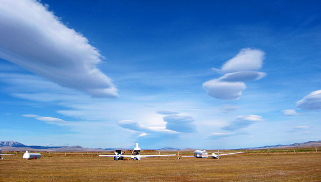
Gorgeous
lennies, Oct 7, 2004, at the fall camp. photo: John Gruber
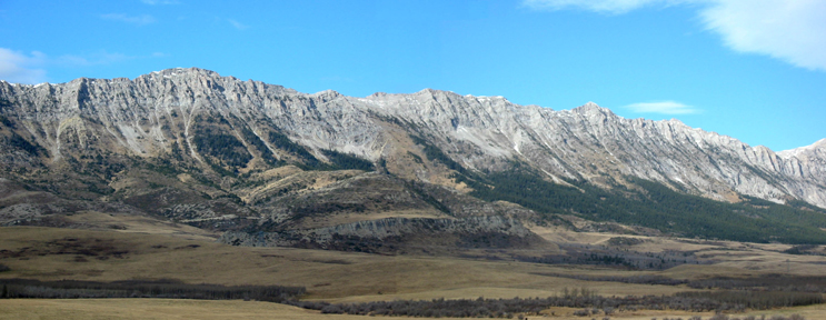
The Livingstone Range close in. The continuous steep
eastern flanks assist the formation of the wave over the
valley. photo:
Margret Simon
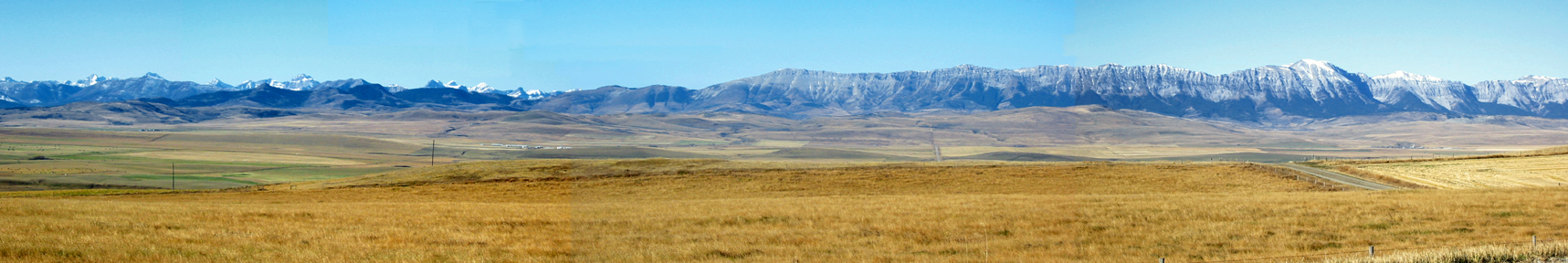
A panorama (scroll to
the right to see the full picture) of the Cowley valley taken from the western
slopes of the Porcupine Hills. The airfield is a little out of frame on the
left. The Crowsnest Pass is above the complex of farm buildings in the middle
distance. The Livingstone Range extends to the north from the Pass, with
Centre Peak above the road in the right portion of the photo. To see the
soaring cairn which is on top of Centre Peak, go to the bottom of this page
and select the link, "The Quest" photo: Margret Simon
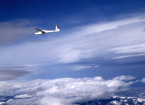
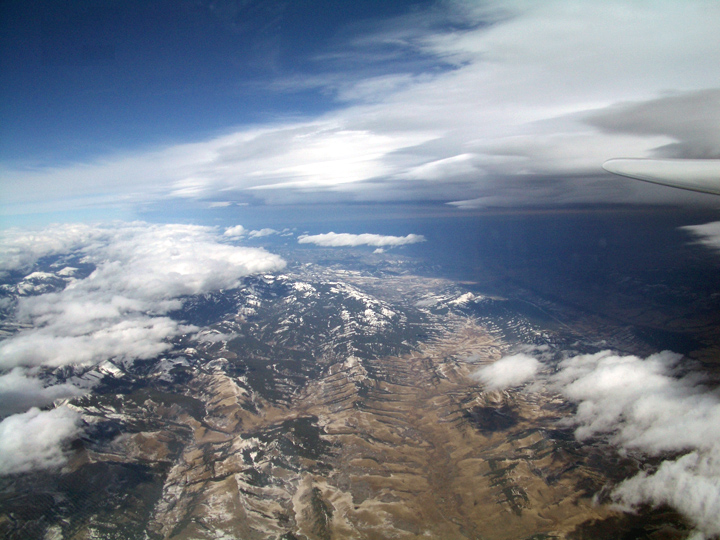
Tony Burton flies his
Russia AC-4C in the wave at 22,000 feet NW of Cowley on 6 Oct 2005.
There was a great
Chinook Arch that day back over the Porcupine Hills.
photo: Tim O'Hanlon
Etc.
There is a lot to do and see besides flying, with
boating on the Oldman reservoir and several excellent attractions nearby (such
as the Frank Slide, Head-Smashed-in Buffalo Jump, and Waterton National Park).
Go to the Travel Alberta
Southwebsite for area travel and sightseeing info and links. For
more information and stories unique to Cowley, go to: * "The Quest"— the story behind the soaring cairn on
Centre Peak * Index of the history of Diamond and record
flights at Cowley